


_0001.jpg)

.jpg)


.jpg)


.jpg)


WITH the latest upgrade to its Quantm software, Trimble has further enhanced alignment planning capabilities for roads and railway designers.
Version Eight of Trimble’s Quantm system continues to provide the most comprehensive planning and costing solution available for road and rail designers with enhancements that offer a more seamless transition from planning to design with greater data integrity, says a spokesman for the US-based company.
Easy data transfer between the Quantm Alignment Planning System and Bentley’s OpenRoads software extends the design-to-construction workflow for alignments to include corridor planning in Quantm, he adds.
In addition, change management and tracking functionality preserve the design intent, and accelerate project delivery with a more seamless transfer of information from planning through design and construction.
“Trimble’s collaboration with Bentley is delivering real-world solutions to transform the design to construction workflow,” says Roz Buick, vice-president for Trimble’s heavy civil construction division.
“By supporting enhanced rich data transfer with Bentley’s OpenRoads software and i-Models, Quantm Version Eight brings new value to our alignment planning customers.”
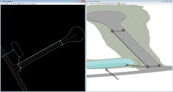
Now available worldwide, the new version produces accurate geometric alignments that can be used in the design and construction phases of a project. The geometric parameters and enhanced templates produce highly detailed alignments that result in a more realistic model of the route. Geometric alignments also deliver enhanced data fidelity and can result in more accurate costing at the early phases of a project for better communication between the designers and builders of new road and rail projects.
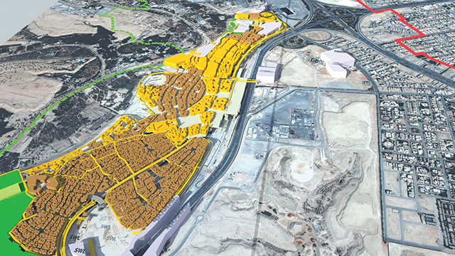
In addition, improved geometric optimisation functionality allows planners to produce data-rich, realistic graphics for client and public consultations. Satellite image overlays and Trimble SketchUp data warehouse models can be included to convey a real-world 3D representation of the design.
The Trimble Quantm system integrates engineering, environmental, social and economic factors into a simultaneous analysis of alternatives for rail and road planning. It allows infrastructure planners to thoroughly examine all alternatives and select the most appropriate corridors for roads and railways.
“The holistic approach to planning new linear infrastructure can result in reduced planning time and cost, faster decision-making and lower construction costs. Projects of all types and sizes – from regional, state and national transportation infrastructure planning to small bypasses and road realignments – can take advantage of the benefits of the Trimble Quantm system. In addition, the system can be used for mining, forestry and utility industry road and rail infrastructure,” says the spokesman.
Trimble provides solutions that are focused on applications requiring position or location – including surveying, construction, agriculture, fleet and asset management, public safety and mapping. In addition to utilising positioning technologies, such as GPS (global positioning system), lasers and optics, these solutions may include software content specific to the needs of the user.

.jpg)